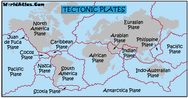
Tectonic Plates:
The video above shows how the movement of the tectonic plates have shaped the land forms we know today, as well as the prediction of how earth will look in the future. The earth surface in composed of tectonic plates that move a few centimeters each year. Convection currents beneath the plates is what causes them to move. Convection occurs because the density of a fluid is related to its temperature. Hot rocks lower in the mantle are less dense than their cooler counterparts above. The hot rock rises and the cooler rock sinks due to gravity. The edges of these plates, where they move against each other, are sites of intense geologic activity, such as earthquakes, volcanoes, and mountain building. Plate tectonics is a relatively new theory and it wasn't until the 1960's that Geologists, with the help of ocean surveys began to understand what goes on beneath our feet.

The land forms of today seem to fit together like a jigsaw puzzle. (you can see this in the video above) If you look at a map, Africa seems to snuggle nicely into the east coast of South America and the Caribbean sea. In 1912 a German Scientist called Alfred Wegener proposed that these two continents were once joined together then somehow drifted apart. He proposed that all the continents were once stuck together as one big land mass called Pangea. He believed that Pangea was intact until about 200 million years ago.
The idea that continents can drift about is called, not surprisingly, continental drift.
When Wegener first put forward the idea in 1912 people thought he was nuts. His main difficulty in proving he was correct was that he knew the continents had drifted but he couldn't explain how they drifted. The old (AND VERY WRONG!!) theory before this time was the "Contraction theory", which suggested that the planet was once a molten ball and in the process of cooling the surface cracked and folded up on itself. The big problem with this idea was that all mountain ranges should be approximately the same age, and this was known not to be true. Wegener's explanation was that as the continents moved, the leading edge of the continent would encounter resistance and thus compress and fold upwards forming mountains near the leading edges of the drifting continents. Wegener also suggested that India drifted northward into the Asia forming the Himalayas and of course Mount Everest.
It is hard to imagine that these great big solid slabs of rock could wander around the globe. Scientists needed a clue as to how the continents drifted. The discovery of the chain of mountains that lie under the oceans was the clue that they were waiting for.
The mid-Atlantic Ridge is an area where new sea floor is being created. As the rift valley expands two continental plates have been constructed from the original one. The molten rock continues to push the crust apart creating new crust as it does. As the rift valley expands, water collects forming a sea. The Mid-Atlantic Ridge is now 2,000 meters above the adjacent sea floor, which is at a depth of about 6,000 meters below sea level. The sea floor continues to spread and the plates get bigger and bigger. This process can be seen all over the world and produces about 17 square kilometers of new plate every year. Plates being created at the mid-ocean ridges seems to be a good idea but if this is the only type of plate movement then the world would get bigger and bigger. In fact the world has remained the same size. So if plates are being created at the mid-ocean ridges then they must be being consumed somewhere else in the world.
The amount of crust on the surface of the earth remains relatively constant. Therefore, when plates diverge and form new crust in one area, the plates must converge in another area and be destroyed. An example of this is the Nazca plate being subducted under the South American plate to form the Andes Mountain Chain. The top layer of the mantle and the crust (all called the lithosphere) sinks beneath the continent, and a deep ocean trench is formed. Water gets carried down with the oceanic crust and the rocks begin to heat up as they travel slowly into the earth. Water is then driven off triggering the formation of pools of molten rock which slowly rises. The plate moves downwards at a rate of a few centimeters per year. The molten rock can take tens of thousands of years to then either: solidify slowly underground as intrusive igneous rock such as granite or reach the surface and erupt as lava flows. Cooling rapidly to form extrusive igneous rock such as basalt. The floor of the Easter Pacific is moving towards South America at a rate of 9 centimeters per year. It might not seem much but over the past 10 million years the Pacific crust has been subducted under South America and has sunk nearly 1000 kilometres into the Earth's interior. The key to subduction seems to be water which acts as a kind of lubricant as the heavier plate slips underneath the lighter plate.
When two oceanic plate meet each other (oceanic-oceanic) this often results in the formation of an island arc system. As the sub-ducting oceanic crust melts as it goes deeper into the Earth, the newly-created magma rises to the surface and forms volcanoes. If the activity continues, the volcano may grow tall enough to breech the surface of the ocean creating an island.
Millions of years ago India and an ancient ocean called the Tethys Ocean sat on a tectonic plate. This plate was moving northwards towards Asia at a rate of 10 centimeters per year. The Tethys oceanic crust was being subducted under the Asian Continent. The ocean got progressively smaller until about 55 million years ago when India 'hit' Asia. There was no more ocean left to lubricate the subduction and so the plates welled up to form the High Plateau of Tibet and the Himalayan Mountains. The continental crust under Tibet is over 70 kilometers thick. North of Kathmandu, the capital of Nepal, is a deep gorge in the Himalayas. The rock here is made of schist and granite with contorted and folded layers of marine sediments which were deposited by the Tethys ocean over 60 million years ago.
Another type of plate movement involves plates sliding past one another without the construction or destruction of crust. This boundary is called a conservation zone because plate is neither created nor destroyed An example of such a boundary is the San Andreas fault in California. The force needed to move billions of tonnes of rock is unimaginable. When plates move some of the energy is released as earthquakes. These earthquakes have caused us other disasters such as title-waves.
No comments:
Post a Comment